
Strong mag. 6.7 earthquake – Off Coast of Central Chile on Sunday, 27 December 2020 at 21:39 (GMT) – information
–
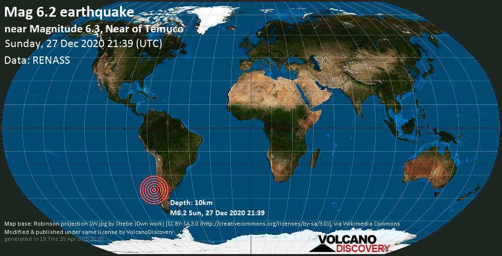
Strong magnitude 6.7 earthquake at 27 km depth

27 Dec 21:43 UTC: First to report: GFZ after 4 minutes.
27 Dec 21:45: Magnitude recalculated from 6.5 to 6.4. Epicenter location corrected by 24 km (15 mi) towards E.
27 Dec 22:04: Now using data updates from GUG (U. Chile)
Update Sun, 27 Dec 2020, 21:48
Significant 6.5 quake hits near Valdivia, Provincia de Valdivia, Los Rios Region, Chile
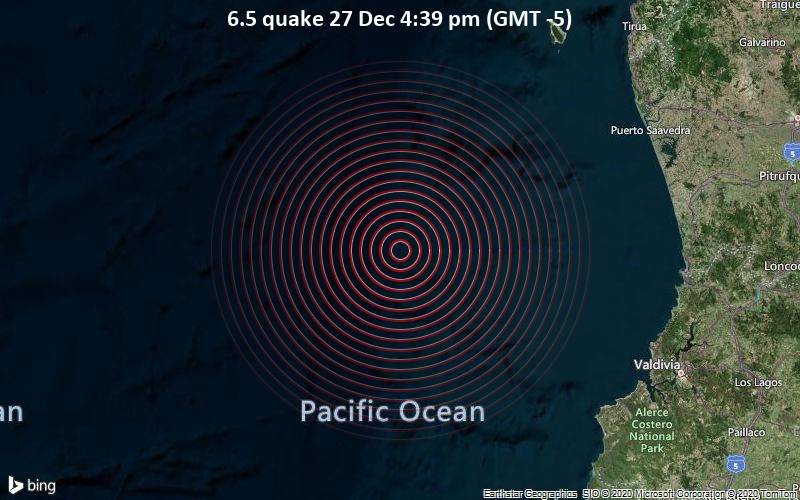
6.5 quake 27 Dec 4:39 pm (GMT -5)
According to preliminary data, the quake was located at a shallow depth of 10 km. Shallow earthquakes are felt more strongly than deeper ones as they are closer to the surface. The exact magnitude, epicenter, and depth of the quake might be revised within the next few hours or minutes as seismologists review data and refine their calculations, or as other agencies issue their report.
A second report was later issued by the European-Mediterranean Seismological Centre (EMSC), which listed it as a magnitude 6.8 earthquake. A third agency, the United States Geological Survey (USGS), reported the same quake at magnitude 6.8.
Based on the preliminary seismic data, the quake was probably felt by many people in the area of the epicenter. It should not have caused significant damage, other than objects falling from shelves, broken windows, etc.
In Valdivia (pop. 133,400) located 143 km from the epicenter, Las Animas (pop. 30,000) 145 km away, and Carahue (pop. 11,900) 154 km away, the quake should have been felt as light shaking.
VolcanoDiscovery will automatically update magnitude and depth if these change and follow up if other significant news about the quake become available. If you’re in the area, please send us your experience through our reporting mechanism, either online or via our mobile app. This will help us provide more first-hand updates to anyone around the globe who wants to know more about this quake.
If you were or still are in this area during the quake help others with your feedback and file a quick report here.
Earthquake data:
I felt this quake
I didn’t feel it
Date & time: 27 Dec 2020 21:39:17 UTC –
Local time at epicenter: Sunday, 27 Dec 4:39 pm (GMT -5)
Magnitude: 6.7
Depth: 26.5 km
Epicenter latitude / longitude: 39.331°S / 74.821°W ![]() (South Pacific Ocean, Chile)
(South Pacific Ocean, Chile)
Nearest volcano: Quinchilca (244 km / 152 mi)
Nearby towns and cities:
145 km (90 mi) WNW of Valdivia (pop: 133,400) –> See nearby quakes!
159 km (99 mi) WSW of Carahue (Cautín) (pop: 11,900) –> See nearby quakes!
174 km (108 mi) WSW of Nueva Imperial (Cautín) (pop: 18,800) –> See nearby quakes!
183 km (114 mi) NW of La Union (Ranco) (pop: 26,300) –> See nearby quakes!
188 km (117 mi) W of Loncoche (Cautín) (pop: 15,600) –> See nearby quakes!
200 km (124 mi) NW of Osorno (pop: 135,800) –> See nearby quakes!
203 km (126 mi) WSW of Temuco (pop: 238,100) –> See nearby quakes!
286 km (178 mi) NW of Port Montt (pop: 160,100) –> See nearby quakes!
741 km (460 mi) SSW of Puente Alto (pop: 510,400) –> See nearby quakes!
752 km (468 mi) SSW of Santiago (pop: 4,837,300) –> See nearby quakes!
232 km (144 mi) WNW of Isla Guilleifa Island –> See nearby quakes!
361 km (224 mi) NNW of Isla Butachauques Island –> See nearby quakes!
Clear Sky
 18.4°C (65 F), humidity: 88%, wind: 4 m/s (8 kts) from W
Primary data source: GUG (U. Chile)
Estimated released energy: 7.1 x 10¹⁴ joules (197 gigawatt hours, equivalent to 1.7 x 10⁵ tons of TNT or 10.6 atomic bombs!) More info

Also if you did NOT feel the quake although you were in the area, please report it! Your contribution is valuable also to earthquake science and earthquake hazard analysis and mitigation efforts. You can use your device location or the map to indicate where you were during the earthquake. Thank you!
Data for the same earthquake reported by different agencies
Info: The more agencies report about the same quake and post similar data, the more confidence you can have in the data. It takes normally up to a few hours until earthquake parameters are calculated with near-optimum precision.
| Magnitude | Depth | Location | Source |
| M 6.7 | 27 km | 144 Km Al O De Toltén, Chile | GUG (U. Chile) |
| M 6.7 | 10 km | 140 Km WNW of Corral, Chile | USGS |
| M 6.7 | 10 km | OFF COAST OF LOS LAGOS, CHILE | EMSC |
| M 6.8 | 17 km | Off Coast of Central Chile | GeoAu |
| M 6.6 | 9.8 km | Chile (Peruvian Point of View) [Sea] | INGV |
| M 6.7 | 10 km | Off Coast of Central Chile | GFZ |
User reports for this quake (44)
Contribute:
Leave a comment if you find a particular report interesting or want to add to it.
Flag as inappropriate.
Mark as helpful or interesting.
Send your own user report!
184.6 km SE of epicenter [Map] / Strong shaking (MMI VI) / 10-15 s : Short but intense. Started slowly and had two peaks of intensity. Went away really fast. | One user found this interesting.
Temuco, Chile (198.3 km ENE of epicenter) [Map] / Light shaking (MMI IV) / both vertical and horizontal swinging : In Temuco, 55 miles from the coast, we felt it long, hard and sonourus. No big deal, anyway. | One user found this interesting.
villa la angostura (314.1 km ESE of epicenter) [Map] / Weak shaking (MMI III)
Osorno (195.7 km SE of epicenter) [Map] / Light shaking (MMI IV) / 5-10 s
310.6 km ESE of epicenter [Map] / Light shaking (MMI IV) / horizontal (sideways) swinging / 1-2 s : Movimiento horizontal de muebles y vibración en ventanas. San Martín de Los Andes
251.1 km SE of epicenter [Map] / Moderate shaking (MMI V) : Estaba en la playa en el Lago Llanquihue
San carlos de bariloche (343.9 km SE of epicenter) [Map] / Very weak shaking (MMI II)
201 km ENE of epicenter [Map] / Light shaking (MMI IV) / rattling, vibrating / 5-10 s
Pucon (244.6 km E of epicenter) [Map] / Light shaking (MMI IV) / 15-20 s
199.7 km SE of epicenter [Map] / Light shaking (MMI IV) / horizontal (sideways) swinging / 20-30 s
289.8 km SE of epicenter [Map] / Light shaking (MMI IV)
Valdivia (149.6 km ESE of epicenter) [Map] / Moderate shaking (MMI V) / rattling, vibrating / 15-20 s
Alerce (284.7 km SE of epicenter) [Map] / Very weak shaking (MMI II) / horizontal (sideways) swinging
205.3 km ENE of epicenter [Map] / Moderate shaking (MMI V) / 5-10 s
Gorbea (187.1 km E of epicenter) [Map] / Light shaking (MMI IV) / complex motion difficult to describe / 15-20 s : Comenzó como un gran y único choque y luego siguió moderado
310.5 km SE of epicenter [Map] / Weak shaking (MMI III) / rattling, vibrating / 2-5 s
Americana, SP Brazil / not felt
SAN MARTÍN DE LOS ANDES / Light shaking (MMI IV) / 15-20 s
Villa la Angostura / Light shaking (MMI IV)
lago ranco / Strong shaking (MMI VI)
Puerto montt / Very weak shaking (MMI II) / vertical swinging (up and down) / very short
Temuco / Light shaking (MMI IV) / horizontal (sideways) swinging / 20-30 s : I was afraid alot!
Osorno / Weak shaking (MMI III)
Villarrica / Strong shaking (MMI VI) / 5-10 s
Villa La Angostura, Neuquén, Argentina / Light shaking (MMI IV) / horizontal (sideways) swinging / 15-20 s
Valdivia, Chile / Light shaking (MMI IV) / 5-10 s
Try our free app!
Aftershocks of the 6.7 quake South Pacific Ocean, 145 km west of Valdivia, Provincia de Valdivia, Los Rios Region, Chile, 27 Dec 4:39 pm (GMT -5)
More info
Recorded aftershocks, latest first (4 quakes so far, frequently updated):
-
27 Dec 2020 22:39 UTC
| M 3.6 |
22.7 km (14.1 mi) depth
|
23 km (14 mi) distance
| GUG (U. Chile) | Details
-
27 Dec 2020 22:30 UTC
| M 3.4 |
29.3 km (18.2 mi) depth
|
56 km (35 mi) distance
| GUG (U. Chile) | Details
-
27 Dec 2020 22:19 UTC
| M 3.5 |
24.6 km (15.3 mi) depth
|
6 km (4 mi) distance
| GUG (U. Chile) | Details
-
27 Dec 2020 22:02 UTC
| M 3.7 |
18.3 km (11.4 mi) depth
|
16 km (10 mi) distance
| GUG (U. Chile) | Details
Earlier earthquakes in the same area since 1900
Strong mag. 6.7 earthquake – South Pacific Ocean, 145 km west of Valdivia, Provincia de Valdivia, Los Rios Region, Chile, on Sunday, 27 Dec 4:39 pm (GMT -5)
-
Date / time UTC
| Mag |
Depth
|
Age
|
Distance
| Details
-
22 May 1960 19:11
| 9.5 |
25km / 16mi
|
61 years ago
|
180km / 112mi
-
21 May 1960 10:02
| 8.1 |
25km / 16mi
|
61 years ago
|
211km / 131mi
-
22 May 1960 18:56
| 7.8 |
25km / 16mi
|
61 years ago
|
209km / 130mi
-
10 May 1975 14:27
| 7.7 |
6km / 3.7mi
|
46 years ago
|
188km / 117mi
-
27 Feb 2010 08:01
| 7.4 |
35km / 22mi
|
11 years ago
|
174km / 108mi
-
01 Nov 1960 08:45
| 7.4 |
20km / 12.4mi
|
60 years ago
|
98km / 61mi
-
02 Jan 2011 20:20
| 7.2 |
24km / 15mi
|
10 years ago
|
169km / 105mi
-
18 Aug 1974 10:44
| 7.1 |
36km / 22mi
|
46 years ago
|
155km / 96mi
-
14 Feb 1962 06:36
| 7.1 |
30km / 19mi
|
59 years ago
|
236km / 147mi
-
22 May 1960 10:30
| 7.1 |
25km / 16mi
|
61 years ago
|
234km / 145mi
Hint: Click on Date/Time to show latest first
Show all
Map of earlier quakes
Try our free app!


