• Physics 13, 90
A remote laser sensing technology is providing unprecedented insights into the society and economy of ancient Maya.

W. E. Carter et al., American Scientist 107, 30 (2019)
Until about a decade ago, archeologists studying the ancient Maya civilization had to be intrepid explorers, hacking with machetes through the dense forests of Mexico, Guatemala, Belize, and Honduras. But in 2009, an airborne laser-sensing technology called light detection and ranging, or lidar, made a splash in the field, uncovering a sprawling urban expanse at the ancient Maya site of Caracol in Belize. Lidar has since changed archaeology “the way the Hubble Space Telescope revolutionized astronomy,” archeologist Francisco Estrada-Belli said in a 2018 news story. Today, researchers use lidar not only to discover the remains of grandiose architecture but also to build an increasingly detailed picture of ancient Maya economy, society, and everyday life.
Developed shortly after the laser was invented, lidar was initially used to monitor clouds and pollution and to map the Moon’s surface from Apollo spacecraft. It took several decades until its archaeology potential was realized. The 2009 eureka moment came when Arlen Chase, now at Pomona College in California, and colleagues analyzed measurements taken during a flight over Caracol from a small lidar-equipped Cessna airplane. Chase recalls the first time he saw the ruins, causeways, and terraces emerging from the data processing. “It was mind blowing,” he says. In a few days, the data revealed more hidden structures than those discovered in decades of traditional surveys.
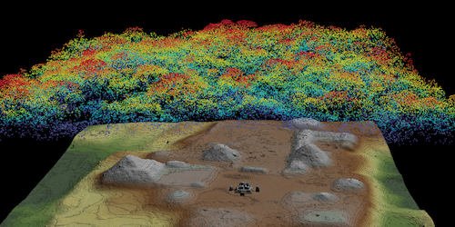
Airborne lidar measurements rely on the basic principles of optics (Fig. 2). From a plane, a laser emits bursts of light pulses as short as a few billionths of a second. These pulses are directed at the ground in a zigzagging pattern as the plane moves. Some of the light from the pulses is reflected, first by the tree crowns and then by the ground or by structures beneath the trees. By recording how long it takes the pulses to return to the plane, researchers can reconstruct the topography of both the vegetation and what lies beneath it. To enable this reconstruction, a GPS system, accelerometers, and gyroscopes continuously and precisely gauge the plane’s position and orientation.

Since 2009, lidar technology has improved, allowing few-centimeter-tall features to be identified in maps that cover thousands of square miles of Central American terrain. “It’s fascinating to see things that people haven’t seen in centuries, and even those who lived at those times couldn’t have this bird’s eye view,” says engineer and pilot Juan Carlos Fernandez-Diaz of the National Center for Airborne Laser Mapping in Texas.
Ongoing surveys are revealing hundreds of thousands of previously unknown Maya structures, such as pyramids, temples, fortresses, plazas, marketplaces, and even private homes. Importantly, lidar can uncover low structures, such as roads and terraced agricultural land, that can be unrecognizable from the ground. Researchers have interpreted these discoveries as evidence that the Maya population was far larger than previously thought, likely reaching 10–15 million people during the society’s golden age—the Maya “Classic” period that lasted from 250 to 900 CE. Lidar-based studies have also reshaped our view of Maya civilization. “The public tends to think of the ancient Maya as a monolithic group. They were not,” Chase says. The data suggest profound regional diversities, with urban and rural areas that traded with each other over an expansive transportation network. “Thanks to lidar, we are now better able to look at boundaries between different areas,” Chase says.
In recent work, Fernandez-Diaz and his collaborators focused on agricultural practices, scanning an area in Belize called Birds of Paradise. The investigation was made possible by a technological advance—the simultaneous use of three lasers with different wavelengths, two infrareds and one green. Since the green beam partially transmits through water, it allows lidar measurements to reveal underwater topography and slight variations in soil water content. With this new sensitivity, the survey delivered the first “crisp and clear” images of an extensive network of canals used for agriculture by the Maya, Fernandez-Diaz says. By combining lidar data with multiple lines of evidence coming from ground-based measurements—carbon dating, excavations, soil, and pollen analysis—the researchers even traced the evolution of agricultural practices from slash-and-burn techniques to organized wetland farming. They also documented the cultivated species, which included maize, squash, and avocado.

T. Beach et al., Proc. Natl. Acad. Sci. U.S.A. 116, 21469 (2019)
The richness of lidar data is helping to sort out the pieces that made up Maya society. Following in the footsteps of his father Arlen Chase, Adrian Chase of Arizona State University applies advanced computational techniques to archeology, tackling subtle nuances of social inequality. In a 2017 study of buildings at the Caracol site, he compared the living spaces available to average households with those available to the Maya elites. From this analysis, he computed a parameter called the Gini index—a statistical measure of income inequality that’s commonly used today. Preliminary results suggest inequality levels on par with some modern Western countries like the US. Although further analysis is needed, the data show a clear trend: inequality rose during the Maya Classic period. “Toward the end of Caracol’s history, we are seeing a much starker division in social classes,” Adrian says.
With such detailed information at hand, one of the biggest archeological mysteries may soon be solved: why did the Maya society collapse between the 8th and the 9th centuries? “We are almost there,” Arlen Chase says. He believes the reason will be found in the increasing interdependence of Maya society. “In a networked system, you are forgetting how to make the goods you need, and a little shake somewhere in the system may bring down the entire network,” he says. And by learning how a society is affected by increasing globalization, rising inequality, and large-scale modifications of the environment, Fernandez-Diaz says, “we may learn valuable lessons on our modern world too.”
–Matteo Rini
Matteo Rini is the Deputy Editor of Physics.


